

Release Date :
Urban population of Caraga increases by 158.03 thousand
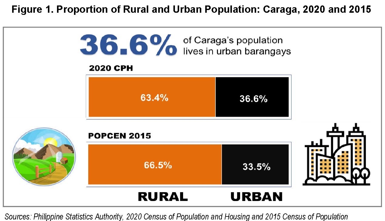
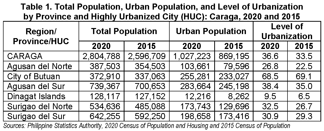
In 2020, 1.03 million or 36.6 percent of the total 2.80 million population of Caraga lived in urban barangays. This represents an increase of 158.03 thousand persons from the 869 thousand urban residents in 2015. The rural population or those who lived in barangays classified as rural in 2020 comprised the remaining 1.78 million persons or 63.4 percent of the total population. (Table 1)
Level of urbanization improves by 3.2 percentage points
The level of urbanization or the proportion of the total population living in barangays classified as urban was recorded at 36.6 percent in 2020. This is 3.2 percentage points higher than the 33.5 percent level of urbanization in 2015.
Agusan del Norte and Butuan City surpass the regional level of urbanization
Across provinces, Agusan del Sur and the City of Butuan (Capital), the lone HUC of the region, posted a level of urbanization higher than the national level with 38.4% and 68.5%, respectively. On the other hand, Dinagat Islands had the lowest level of urbanization with 9.5 percent.
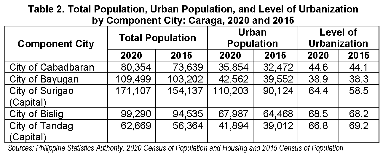
Decline in the level of urbanization in one of the component cities
All the five (5) component cities of the region, except City of Tandag, have improved level of urbanization. The City of Bislig had the highest level of urbanization with 68.5 percent. However, the City of Surigao had the highest increase with 64.4 percent in 2020 compared to 58.5 percent in 2015, or a difference of 5.9 percentage points.
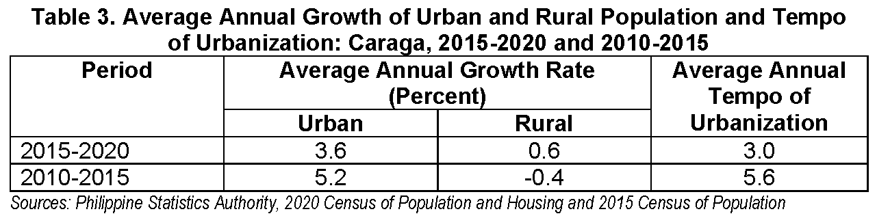
Tempo of urbanization decelerates to 3.0 percent in 2020
Between the period 2015 to 2020, the tempo of urbanization was computed at 3.0 percent. This is lower by 2.6 percentage points compared with the 5.6 percent tempo of urbanization that was posted between the period 2010 to 2015. (Table 3)
The urban population of Caraga increased at an average of 3.6 percent annually during the period 2015 to 2020. In comparison, it is lower than the 5.2 percent average at which the urban population of the country grew annually during the period 2010 to 2015. Moreover, the rural population improved by 0.6 percent annually between the period 2015 to 2020 from a 0.4 percent annual decline between the period 2010 to 2015.
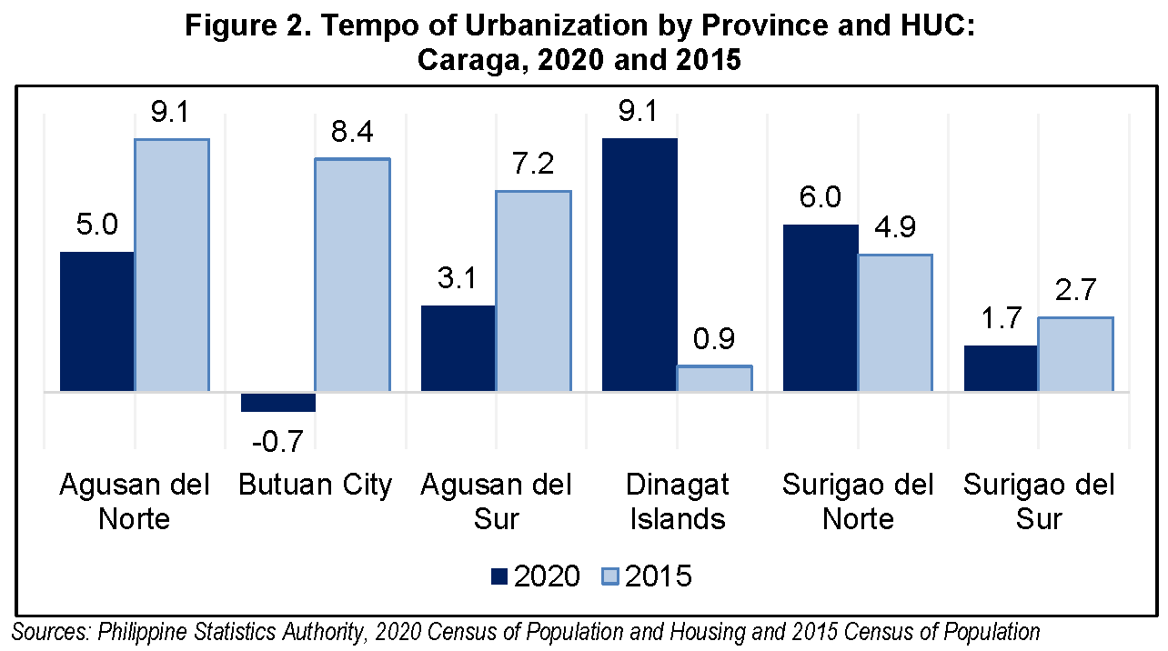
The tempo of urbanization of the three provinces in Caraga, namely Agusan del Norte (5.0%), Agusan del Sur (3.1%), and Surigao del Sur (1.7%) slowed down in 2020. On the contrary, the tempo of urbanization of Dinagat Islands (9.1%) and Surigao del Norte (6.0%) accelerated in the same period. The lone HUC, Butuan City had a negative tempo of urbanization (0-.7%).
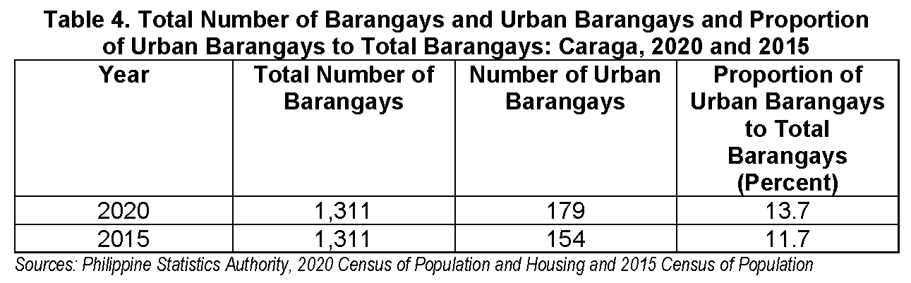
Proportion of urban barangays to total barangays gains 1.9 percentage point
Out of the 1,311 barangays in Caraga in 2020, 179 barangays or 13.7 percent were classified as urban. In 2015, 154 barangays were classified as urban, representing 11.7 percent of the total barangays during that year.
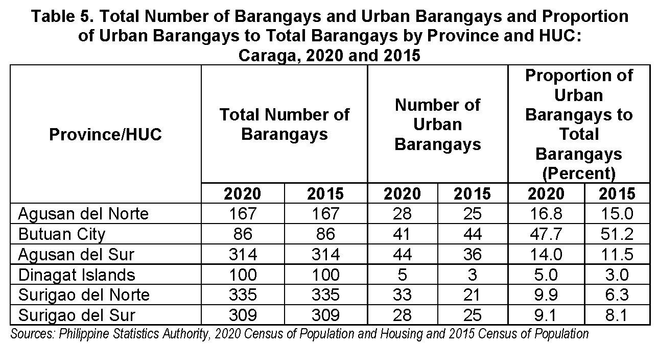
Among the five provinces, Agusan del Norte have the highest proportion of urban barangays (16.8%) in 2020. It is followed by Agusan del Sur with 14.0 percent. In contrast, Dinagat Islands had the least proportion of urban barangays (5.0%).
TECHNICAL NOTES
Introduction
The Philippine Statistics Authority (PSA) conducted the 2020 Census of Population and Housing (2020 CPH) in September 2020 with 01 May 2020 as reference date. This was the 15th census of population and the 7th census of housing in the Philippines since the first census was undertaken in 1903.
The 2020 CPH was designed to take an inventory of the total population and housing in the country and collect information about their characteristics. It aimed to provide government executives, policy makers, and planners with population and housing data, particularly updated population count of all barangays in the country, for use as bases in their social and economic development plans, policies, and programs.
Definition of Terms
A barangay is the smallest political unit in the country. The official list of barangays of the Department of the Interior and Local Government (DILG) based on the Philippine Standard Geographic Code (PSGC) as of 31 December 2020 was used during the 2020 CPH operations. For purposes of this publication, the PSGC as of 31 March 2022 was used as reference, to reflect the new composition of the Bangsamoro Autonomous Region in Muslim Mindanao (BARMM).
Based on PSA Board Resolution No. 01 Series of 2017-098 (National Statistical Coordination Board – Board Resolution No. 09 Series of 2003), which was approved on 13 October 2003, a barangay is classified as urban if it meets any of the following:
It has a population size of 5,000 or more; or
It has at least one establishment with a minimum of 100 employees; or
It has five or more establishments with 10 to 99 employees, and five or more facilities within the two-kilometer radius from the barangay hall.
Further, all barangays in the National Capital Region (NCR) are automatically classified as urban.
A barangay which does not satisfy the abovementioned criteria is classified as rural.
The following facilities/services were considered in the classification of a barangay into either urban or rural under Category 3 (see description below):
town/city hall or provincial capitol;
church, chapel or mosque where religious service is held at least once a month;
public plaza or park for recreation;
cemetery;
market place or building where trading activity is carried out at least once a week;
public school buildings (elementary, high school, and college/university);
library;
hospital, puericulture center, barangay health center/station or clinic;
fire station or public fire protection service;
seaport in operation;
community waterworks system;
post office or postal service;
landline telephone system or calling station;
cellular phone signal; and
public street sweeper.
The categories used in classifying a barangay as urban are as follows:
Category Description
1 Barangay with a population size of 5,000 or more
2 Barangay with at least one establishment with a minimum of 100 employees
3 Barangay with five (5) or more establishments with 10 to 99 employees, and five (5) or more facilities within the two-kilometer radius from the barangay hall
Urban population refers to persons living in urban areas/barangays.
Level of urbanization is the proportion of the urban population to the total population in a specific period. It is calculated by dividing the urban population by the total population and multiplying the quotient by 100.
The tempo of urbanization is an indicator to express the speed at which an area is moving toward an urban classification. In this report, it is calculated by taking the difference between the growth rate of the urban population and the growth rate of the rural population.
The average annual growth rate is computed using the geometric formula:
𝑟= {(𝑃𝑡+𝑛𝑃𝑡)1𝑛 −1} 𝑥 100
where:
𝑟 = average annual growth rate of the urban or rural population
𝑃𝑡 = urban or rural population from the previous census
𝑃𝑡+𝑛 = urban or rural population from the current census
𝑛 = time interval (expressed in years) between the current census
and the previous census
A population is believed to increase in a geometric fashion, that is, it changes at a rate wherein the increments are compounded over a specific period.
Method of Enumeration
The Head Census Area Supervisor (Head CAS), who was a regular PSA personnel, was assisted by the hired CAS in administering the CPH Form 5, through a face-to-face interview with the Punong Barangay or any knowledgeable barangay official. Some conducted the interview during the regular meeting of the Association of Barangay Captains (ABC) or Liga ng mga Barangay even before the start of the census, that is, at the height of the coordination activities of the PSA officials and personnel with the officials of local government units. Otherwise, it was recommended that the face-to-face interview in the barangay be done during the middle of the enumeration period when ocular inspection of the barangay has already been made. During that time, it was expected that the interviewer has already familiarized himself/herself with the boundaries, characteristics, facilities, and establishments present in the barangay and its neighboring barangays.
Respondent of CPH Form 5
The respondent of CPH Form 5 was an official of the barangay who provided information about the characteristics and facilities in the barangay and its neighboring barangays, establishments situated in the barangay, informal settlers, number of households in relocation areas in the barangay, if any, as well as the inmovers/outmovers to/from the barangay and the barangay/s of origin/destination. The respondent was either the Punong Barangay, Barangay Councilor, Barangay Secretary, Barangay Treasurer, or any other knowledgeable barangay official.
Approved by:
(Sgd.)ROSALINDA C. APURA, D.M.
Regional Director, PSA-RSSO XIII
Telephone number: (085) 225-5219 / Telefax No.: (085) 815 – 4935
Email address: psacaraga_rsso13@yahoo.com.ph
| Attachment | Size |
|---|---|
|
|
927.01 KB |